Trekking is referred to a journey on foot whereby there are no means of transport available.Trekking leads to exploring such places which are generally in interiors and have a very less footfall of human beings.Such places, hence, are very natural, due to less human interference and gives a peace of mind to
.It is a state which has been blessed by nature and there are plenty of Himalayan treks available for trekking. The treks vary from soft to hard and offer a variety to the experienced trekkers. Whether it be the meadows of Deoria Taal or the majestic views of Chandrashila, every trek has something unique to offer the visitors.
runs away with the show.The place is located in the Chamoli district of Uttarakhand at a height of 3350 metres above sea level.The trek consists of lush green grass meadows, coniferous forests and steep climb ways.
One needs to start from the Lohajang Pass which has a connectivity of motorable road.The trek passes from village for about 11 kms and ends at Wan village.The first 7 to 8 kilometers is a descending path while the latter part is an ascending one.
Deoria Tal is a treasure of nature gifted to
Uttarakhand with a non comparative beauty.The place is located at a height of 3200 metres and has a tendency to captivate anyone with its mesmerizing beauty level.The story behind the place is referred where the Pandavas were asked questions by the Yaksha before having water.The lake has a surrounding of soothing fields and is set magnificently in the lap of peaks.
Chopta is one of those unspoiled places in Himalayan range which is less known to people and hence is passed by many of them. The place appears to be one from Swiss map due to the heavenly beauty and is often reffered to as Mini Switzerland also. It is an alpine meadow at a height of 2500 meters and is a protected sanctuary.The flora consists of pines, rhododendrons, oaks and deodars at their full flourish. There is an ancient track towards the Tungnath temple which gives an unparalleled view of the Himalayan peaks
The winters convert everything with a white blanket of snow and the summer Green meadows of Chopta convert into white during winters.
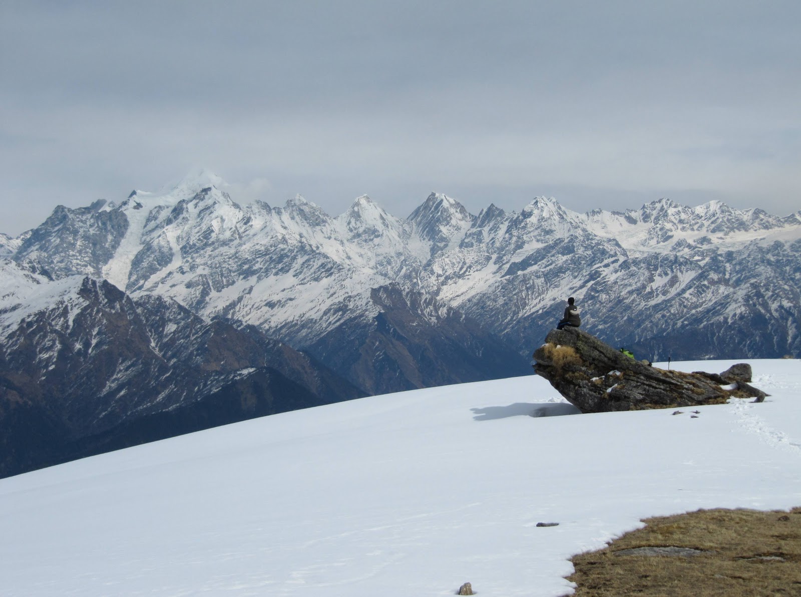
Chandrashila peak offers a majestic view of 360 degree of snow clad Himalayas. All major peaks including Nanda Devi, Chaukhamba and Trishul can be seen in on a clear day from Chandrashila.
Chopta – Chandrashila is one of the favorite Indian trekking destinations.

How to reach Deoria Tal:
Chopta is reachable through Ukhimath as well as Gopeshwar.Chopta is the starting point for trekking to Tungnath and further to Chandrashila.The best time to visit Chopta is from June to November.
Rating: Easy to Moderate
Best Season: Round the year
Gangotri (3048m) – Gaumukh (3892m), Garhwal Uttarakhand:Alright, now we come to a trek which is very famous and well known amongst the tourist/trekkers.There are enormous delights most of which are unexpected. With every moving step, the scenery which is already so magnificent unfolds itself.
The stream viewed Kedar Ganga meets the Bhagirathi at Gangotri surrounded by the brilliant snow peaks, Brahma, The Gangea Mandir, Shankracharya and the mighty Shivling, which is called as Dev Ghat, the starting nudge to Dev Ganga.
Gaumukh is 19km north east of Gangotri. Gaumukh can be seen at the foot of Shivling (a striking un-scaled pinnacle of rock & ice). Forbiddingly beautiful, the awesome Shivling Peak looms, 6,540m above the source of Ganga at the Gangotri Glacier evokes a mystical atmosphere descending from beyond.
Gaumukh is the source to Indias most sacred river – Ganges whereby it flows from Gangotri glacier, which is a giant 30 kms long glacier.It is surrounded by mighty peaks of Shivling, Meru and the three Bhagirathi peaks while Chaukhamba being the highest peak .
The Chaukhamba cluster of snow peaks, while the three Bhagirathi peaks tower the Gaumukh springs as if these mountains were the embodiments of Shiva.

How to reach Gangotri:
Gangotri is well connected by motorable roads to most of the destinations in Uttarakhand.The nearest airport is Jolly Grant which is 250 Km from here.The nearest railway station is in Rishikesh which is situated nearly 234 Km from here.This remaining part of the journey is completed by road.
Rating : Moderate with weather unpredictable
Season: Feb to November
Har Ki Doon (3566m), Garhwal Uttarakhand:Har ki Doon is located in the west part of Garhwal at an altitude of 3566 meters between dense forests and peaks.There is enormous flora and fauna on the way to the trek and is a paradise for bird watching and wild life lovers.
The name behind the place has a holy history whereby Hari meaning God and Dun meaning valley.Duryodhan is identified as God in this part of the world and has a temple on his name and it is believed that Pandavas went to Swarg through this mountain.The,valley has rare Brahamkamal, Bhojpatra trees, some best variety of Pine and Deodar trees.The trek is an attraction to all age groups and is a must visit for photography lovers.
Har ki Doon is the base point for Swargarohini which is situated at a height of 6400 meters and has BandarPoonch mountain on its western range.Most of the houses on the way can be observed having carvings of Mahabharata.The place is gaining an important place in terms of tourism and the foot fall is increasing
The route consists of Drive from Dehradun to Mussoorie to Sankri, Kampty falls and the Yamuna River, you will be visiting remote historical and cultural place of Jounsar-Bawar, Rawal, Jounpur and to the legendry & mythological temples of Lakhmandal (the exile of Pandavas) to Taluka Village, to Osla and then to Har-ki-Doon the trek is through terraced mountain fields, lush green grassy land and the coniferous forest and ultimately reached the wonderful multi-colored flower-ridden meadows of Har-ki-Doon.

How to reach Har Ki Doon:
Buses are easily available from Dehradun to Purola.Buses and taxis can be hired from Purola till Sankri and further till Taluka from where the actual trekking begins.
Rating :Easy
Best Season :March – June & Sept – Mid Nov
Pindari / Kafni Glaciers (3800m and upwards), Kumaon Uttarakhand:Pindari is located at a height of 3820m in Bageshwar district. The Pindari glacier is well connected to the southwestern slope of the Nanda Devi Sanctuary.The major peaks which lie near this glacier are Nandakot (6880m),Pawalidwar (6663m), Nandakhat (6611m), and changuch (6322m) and Baljuri (5922m). It is one of the most accessible glaciers in the Kumaon region.The glacier has a total length of 3 Km and is approximately 0.25 km broad.
The
Kafni glacier is the source to the Kafni River, which is a tributary of the Pindar River. The Pinder River in turn is a tributary to theAlaknanda River, which eventually leads to the Ganges.The region is known for its rich wildlife.

How to reach Pindari Glacier and Kafni Glacier:
The trek starts from Song which is a small village in Almora.The first phase of the trek leads to Dhakuri which is around 14 Km from Song.The next 25 Km or so lead to Phurkia via Dwali from where Pindari is 14 Km away.The Kafni Glacier is 12 Km from Dwali.
Rating : Moderate
Best Season: April to November.
Milam Glacier (3438m and upward), Kumaon Uttarakhand:Milam Glacier is 27 km long and it is considered the biggest glacier in the Kumaon region.Milam village, lying very close to this glacier, is one of the highest villages found in the Himalayan range which is located on the old trade route to Tibet. Munsiyari,apart from being the starting point for
Milam Glacier, is the base point for some other glaciers also among which Namik, Lilam, Poting, and Ralam Glaciers are common. The main peaks found in this region include Kalabulanddhura (6215m)Burphudhura (6215m) and Hardeol (7151m).

How to reach Milam Glacier:
One can drive from Kathgodam till Munsiyari via Almora and Bageshwar.The trek route from Munsiyari till Lilam is mostly downhill after which the route passes through some and downs with an increasing altitude till Rilkot passing through mule bridges and frozen ice streams.The next phase of the trek route upto Milam is a steep climb.
Rating: Moderate
Best Season: May-June and September-October.
Valley of Flowers (3962m), Garhwal Uttarakhand:The valley of Flowers spreads over an area of 85.80 sq km and it is known for its large collection of wild flowers species. A large variety of flowers grow in this region including some ferns & Himalayan herbs. It is home to over 300 species of wild flowers. The valley is associated to the Ramayana and it is said that Hanuman Ji came here to collect Sanjeevani booti herb to revive Lakshman. The Pushpawati river adds to the beauty of the peak with the towering Rataban Peak in the background . The valley offers a once in a lifetime experience to those who are fond of nature. The
Valley of Flowers was found by Frank S. Smythe who was a mountaineer, explorer and a botanist.He camped here for several weeks in the monsoon of 1937 and carried out his exploratory work. He then authored a book known as “The Valley of Flowers” which brought out to the world the beauty which it contained.

How to reach the Valley:
The motorable road begins at Haridwar and connects the valley upto Govind Ghat.The trek route commences from Govind Ghat and the first 13 Km lead to Ghangharia passing through zig zag mule track,terraced fields and vegetation.There are two routes from Ghangaria-one leading to the Sikh shrine Hemkunt Sahib and the other one to the Valley of flowers.
Rating: Moderate
Best Season: June-October is the best season to view this panoramic beauty .For the remaning part of the year the valley is snow covered and difficult to visit.
Roop Kund (4450m), Garhwal Uttarakhand:
Roopkund is a mysterious lake at the altitude of 4450m in the interior of Chamoli district of Uttarakhand. The lake is shallow having a depth of about 2 meters the edge of which is covered with snow for most part of the year. When this snow melts,skeletal remains of humans are visible some of which have flesh attached. Some believe that these remains are of the 300 people who died some 600 years ago. Others believe that they are the General Zorawar’s Soldiers who died in an attempt to conquer Tibet.

How to reach Roop Kund:
The trek route to
Roop Kund starts from Lohajung which is located at an altitude of 2530 meters.The route leads to Bedni Bugyal via Didilana and is moderate.The next phase of the trek is comparatively easy and follows upto Patar Nachauni.The route from Patar till Roopkund has steep ascent in the beginning and a slope later.
Rating: Moderate
Best time to visit: September-October
Sunderdhunga Valley (3206m and upward), Kumaon Uttarakhand:The meaning of ‘Sunderdhunga’ is the valley having beautiful stones. The Sunderdhunga Valley is located to the west side of Pindari valley. The two Glaciers found here are Sukhram and Maiktoli whereas the main peaks comprise of Mrigthuni (6856m), Pawalidwar (6664m),Tharkot (6100m) and Maiktoli (6803m).

How to reach Sunderdhunga:
The route to
Sunderdhunga till Khati is the same as is the trek route to Pindari and Kafni i.e one needs to drive from Kathgodam till Loharkhet from where the trekking begins.The trek leads to Khati which is the biggest village found on the trek to Pindari-Kafni glacier/Sunderdhunga.More than half of this journey passes through thick alpine forests.The two routes that follow lead to two viewpoints-Maiktoli top and Sukhram cave.
Rating: Moderate
Best time to visit: April-June,September-October.
Dodi Tal Trek (3024m), Garhwal Uttarakhand:Dodi Tal is situated in north of Uttarkashi at an elevation of 3024m and is surrounded by dense woods of Pine, Deodar, Oak and Rhododendrons. Rare fishes,including the Himalayan Golden Trout can be found in this crystal clear lake.

How to reach Dodi Tal:
The trek to Dodi Tal commences from Uttarkashi to Sangam Chatti and it is approachable by motor. There is a gradual climb from Sangam Chatti to Agoda which passes through woods, fields, and villages. The trek further from Agoda to Dodi Tal is compararively steep and through thick forests.


 climbing shoes off from this little residence of hills and natural jungles. The name indicates a ‘place with snow’ and when winter months season is kilometers away from the rest of the nation, this position accumulates up smooth layers of snowfall over its natural sheath but the impact only comes out more positive.


